


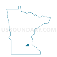
Shakopee P-5, Scott County, Minnesota
About
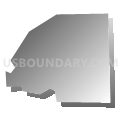
Outline

Summary
| Unique Area Identifier | 604350 |
| Name | Shakopee P-5 |
| County | Scott County |
| State | Minnesota |
| Area (square miles) | 0.57 |
| Land Area (square miles) | 0.57 |
| Water Area (square miles) | 0.00 |
| % of Land Area | 100.00 |
| % of Water Area | 0.00 |
| Latitude of the Internal Point | 44.78258180 |
| Longtitude of the Internal Point | -93.54859990 |
Maps


Graphs
Select a template below for downloading or customizing gragh for Shakopee P-5, Scott County, Minnesota


Neighbors
Neighoring Voting District (by Name) Neighboring Voting District on the Map
- Jackson Twp. Voting District, Scott County, MN
- Shakopee P-1, Scott County, MN
- Shakopee P-6, Scott County, MN